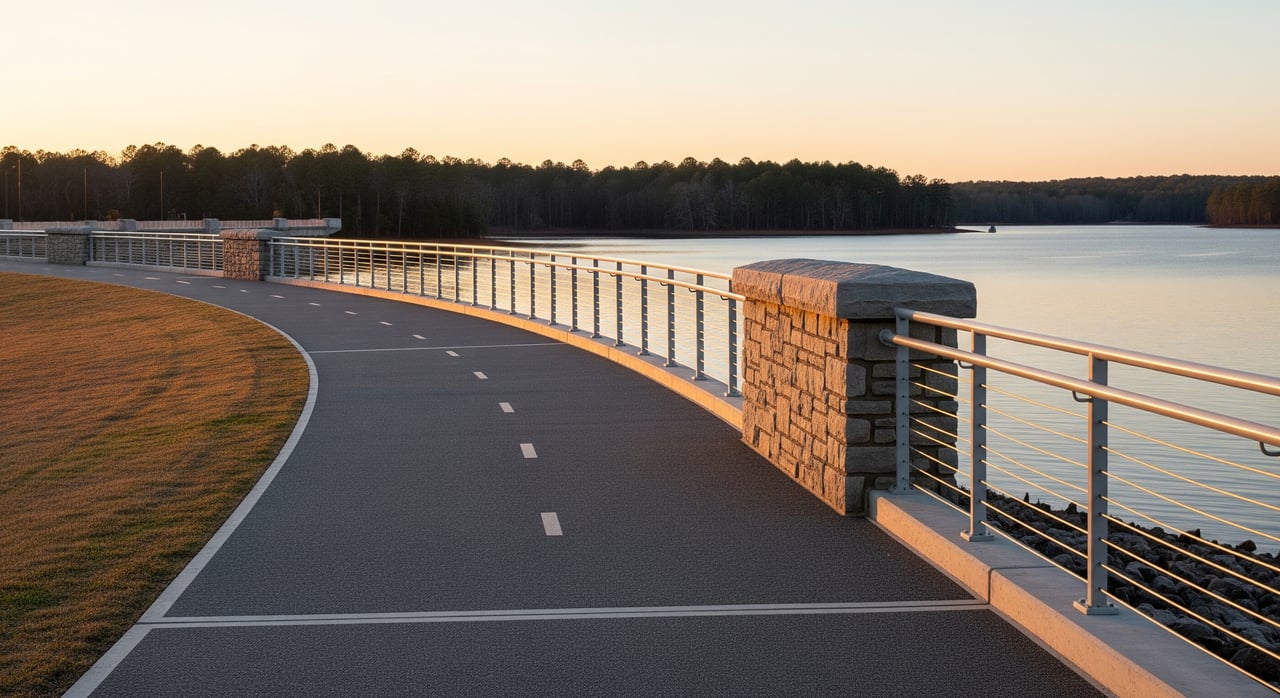
Looking for a simple, scenic workout with sunset views without leaving West Columbia? The 1.7-mile walkway across the Dreher Shoals Dam, often called the Lake Murray Dam, gives you wide-open lake views and a clear path to stretch your legs or spin your wheels. If you plan ahead, you can avoid parking headaches, stay safe, and enjoy the skyline and water in every direction. Here is how to do it right, from access and hours to etiquette and safety. Let’s dive in.
Where the walkway is
The walkway spans the top of the Dreher Shoals Dam on Lake Murray in Lexington County. You are just west of Columbia, near West Columbia and the Saluda River. The direct route is about 1.7 miles across, which makes for a 3.4-mile out-and-back if you turn around at the far end.
You will see walkers, runners, cyclists, photographers, and people out for sunset or sunrise views. Anglers often use nearby access areas, so expect a mix of visitors, especially on nice weekends.
Parking basics and access
Parking rules vary by location and are managed by a mix of local agencies and the dam operator. Expect limited or no formal parking directly on the dam. Most visitors use nearby public lots, boat ramps, or permitted street parking when available. Always follow posted signs and never block driveways or emergency access.
Before you go, confirm the legal parking areas and any fees or time limits through Lexington County, the City of West Columbia, or the dam operator. Peak times like sunset, weekends, and holidays draw crowds, so plan to arrive early or be ready for a short walk from a legal lot. If a big crowd is likely, consider rideshare or alternate access points.
Quick parking tips
- Use official public parking areas when possible. Obey all posted signs.
- If parking on streets, leave space for driveways and emergency vehicles. Do not block private property.
- Arrive earlier at sunset, on weekends, and on holidays when demand is highest.
- If lots are full, choose another legal lot rather than circling in no-parking zones.
Hours and rules to check
Hours can change based on season, maintenance, or security needs. Some facilities allow pedestrian access at all times, while others post opening and closing times. Always obey posted signage at entrances and along the walkway. If you see a closure for weather, maintenance, or security, respect it and do not cross barriers.
Look for posted restrictions at the entrances. Signs may list rules on items like alcohol, amplified sound, fishing from the dam, scooters or skateboards, drones, commercial photography, or organized events. If you are planning anything beyond a casual visit, contact local authorities or the dam operator to confirm whether you need a permit.
If you plan to visit at night
- Verify whether nighttime pedestrian access is allowed. Do not assume it is open 24 hours.
- Check for lighting along the route. Bring a headlamp or flashlight and wear reflectors if you will be out after dusk.
- Stay alert near vehicles and follow all traffic signs.
Share the space: walkway etiquette
This is a shared space used by people moving at different speeds. Good etiquette helps everyone enjoy the views and stay safe.
- Keep to one side so others can pass. Move single-file when the walkway is busy.
- Cyclists should yield to pedestrians, announce passes clearly, and ride at a safe speed.
- Step to the side for photos. Do not block the travel lane when stopping for views.
- Keep dogs leashed and under control. Bring bags and pack out pet waste.
- Respect anglers, crews, and any restricted areas. Do not enter fenced or posted zones.
Safety and comfort tips
Conditions on top of a dam can feel different from nearby streets or parks. A little planning goes a long way.
- Visibility: wear bright or reflective clothing in low light. Carry a light after dusk.
- Traffic awareness: the dam top may be a paved road shared with vehicles or utility trucks. Stay alert and follow signs.
- Surface hazards: watch for uneven pavement, debris, or wet conditions, especially after storms.
- Weather and wind: expect stronger wind and cooler temperatures over the water. Dress in layers.
- Hydration and footing: bring water for longer visits and wear supportive shoes.
- Emergency planning: know nearby landmarks and carry a charged phone. If service is spotty, tell someone your route and return time.
Accessibility and bikes
The top of the dam is typically paved, but accessibility can vary at specific entrances. Some approaches may include stairs, narrow sections, or changes in grade. If you require step-free access, confirm accessible parking, curb cuts, ramps, and restroom availability with Lexington County or the dam operator before you go.
Many shared-use routes allow bicycles. Check posted signs for any bicycle rules at the dam. Cyclists should ride predictably, yield to pedestrians, and use front and rear lights in low light. Helmets are recommended.
Alternate lake-view options
Looking for a shorter, quieter, or fully accessible visit? Research county or state-managed parks, boat ramps, and public lake access areas around Lake Murray. These locations often include formal parking, restrooms, and designated trails. If the dam is crowded or closed, these spots can give you the same water views with less stress.
Plan your visit checklist
- Verify current hours, closures, and parking rules through Lexington County, the City of West Columbia, or the dam operator.
- Plan your arrival time for parking. Sunset and weekends fill up fast.
- Park legally in public lots or permitted street parking. Do not block driveways or emergency access.
- Wear visible clothing. Bring a light if visiting near dusk or after dark.
- Keep dogs leashed. Bring bags to pick up waste.
- Use pull-outs or the edge for photos. Do not block through traffic.
- Respect all signs and restricted areas. Do not climb railings or cross barriers.
- Bring water, check the forecast, and let someone know your route and return time.
- For events, drones, or commercial shoots, contact local authorities or the dam operator about permits.
Why locals love it
The Lake Murray Dam walkway delivers big views with simple logistics. You can set an easy pace, catch sunrise or sunset over the water, and clear your head while staying close to home in West Columbia and Lexington County. It is a great place to bring visiting friends, snap photos, and enjoy Columbia’s skyline in the distance.
Considering a home near Lake Murray?
If you love the dam path and lake lifestyle, living near Lake Murray can make it part of your daily routine. From quiet coves to amenity-rich neighborhoods around Lexington and Chapin, there are options for a range of budgets and goals. When you are ready to explore, The SC Key Group is here to help you compare areas, weigh commute and access, and find the right fit. Request Your Home Valuation to understand your buying power and timing.
FAQs
How long is the Lake Murray Dam walkway?
- The direct route across the Dreher Shoals Dam is about 1.7 miles. An out-and-back totals roughly 3.4 miles.
Where can you park for the Lake Murray Dam walk?
- Use official public lots, boat ramps, or permitted street parking, and always follow posted signs. Do not block driveways or no-parking zones. For exact locations and any fees or limits, confirm with Lexington County, the City of West Columbia, or the dam operator.
What are the hours for walking the dam?
- Hours can change with season, maintenance, or security. Check posted signage at entrances or contact Lexington County, the City of West Columbia, or the dam operator before you go.
Are bikes allowed on the dam walkway?
- Many shared-use routes allow bicycles, but rules are site-specific. Check posted signs, yield to pedestrians, ride at safe speeds, and use lights in low light.
Can you fly a drone or do a photo shoot on the dam?
- Critical infrastructure areas often restrict drones and may require permits for commercial photography or events. Confirm current rules with the dam operator and local authorities before planning a shoot.
Is the walkway accessible for wheelchairs or strollers?
- The surface is typically paved, but access points vary. Confirm accessible parking, curb cuts, ramps, and restrooms with Lexington County or the dam operator if step-free access is essential.
